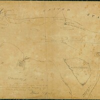
Map showing the action around Navy Island during the Rebellion of 1837 and the spot where the Caroline Steamer was cut out, 1838.
Item
- Title
- Description
- Creator
- Date
- Subject
- Source
-
Map showing the action around Navy Island during the Rebellion of 1837 and the spot where the Caroline Steamer was cut out, 1838.
-
Map backed on linen, prepared by J.G. Chewett, Surveyor’s General Office. The map is a “copy from Mr. [David] Thompson’s Map of the Boundary line between Upper Canada and the United States”, showing the action around Navy Island during the Rebellion of 1837 and the spot where the Caroline Steamer was cut out. Lithographed by H.I. Castle, 1838.
-
Castle, H.I.
-
1838
-
Upper Canada
United States
Navy Island
-
Jarvis family fonds, 1789-1847, n.d. RG 563, Archives and Special Collections, Brock University Library.