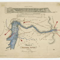
Sketch of Niagara River between Queenston and Chippawa
Item
- Title
- Description
- Creator
- Subject
- Source
-
Sketch of Niagara River between Queenston and Chippawa
-
Sketch of Niagara River between Queenston and Chippawa (coloured). Red arrows affixed to the map mark certain locations, including Lewiston; Queenston; the crossing over the Niagara River between Queenston and Lewiston; Portage Road; Ferry Miles (2 ½) over the River between Fort Schlosher and Chippawa Creek; and Chippawa. The map is engraved by J & C Walker, n.d.
-
J & C Walker
-
Map
Queenston (Ont.)--History
-
Alexander Hamilton/Early Canada Postal collection, RG 699, Archives and Special Collections, Brock University
- Item sets