Map of the Niagara Frontier, 1818
Item
Title
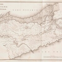
Map of the Niagara Frontier, 1818
Description
A map of the Niagara Frontier from Travels in Canada and the United States
in 1816 and 1817 by Lieut. Francis Hall, 14th Light Dragoons, dated May 20,
1818. It depicts the Niagara Peninsula with communities, roads, creeks, some topography features, and forts used during the War of 1812, including Fort Mississauga, Fort Niagara, Fort George, Fort Drummond and Fort Erie. Some
battle sites of the war are noted on the map, including Lundy’s Lane, Queenston, Chippawa, and Beaver Dams. The map was published by
Longman, Hurst, Rees, Orme, & Brown and engraved by Sidney Hall. Colour has been added to some portions of the map.
Creator
Hall, Sidney
Date
1818-05-20
Subject
Canada--History--War of 1812
Source
Map of the Niagara Frontier, 1818, RG 566, Archives and Special Collections, Brock University. A copy of this map appears in Travels in Canada and the United States in 1816 and 1817 (SPCL FC 72 H34 1818).