Map of the Villages of Niagara Falls, & Niagara City, New York : The Village of Elgin and the City of the Falls, Canada West
Item
Title
Map of the Villages of Niagara Falls, & Niagara City, New York : The Village of Elgin and the City of the Falls, Canada West
Description
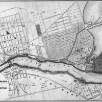
Historical map showing Niagara Falls, New York located to the east of the Niagara River and Canada West (now Ontario), to the west of the Niagara River. A dotted line runs through the centre of the Niagara River indicating the “National Boundary”. On the Canadian side of the river, the “City of the Falls”, current City of Niagara Falls, and Elgin are shown with main streets labelled as well as ownership of lots noted be last name. Streets and subdivisions are shown as well as. The Canadian and American Falls are labelled along with Goat Island and Bath Islands, which sit at the top of the falls in the river. The Erie and Ontario Rail Road is also indicated, running from the United States, over a bridge crossing the Niagara river and continuing north through Niagara Falls. Samuel Zimmerman's property is labelled.
Creator
J. H. Bufford’s Lith. Boston
Date
1854?
Subject
Village of Elgin
City of the Falls, Canada West
Niagara Falls, Ontario--History
City of the Falls, Canada West
Niagara Falls, Ontario--History
Source
Digital reproduction: Library and Archives Canada, National Map Collection: NMC-4219. Original map size 14 x 20 ½ inches. Georeferenced and modified by Map, Data and GIS Library, Brock University.