Sketch of Niagara Falls, the Rapids and Vicinity
Item
Title
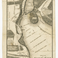
Sketch of Niagara Falls, the Rapids and Vicinity
Description
Sketch of Niagara Falls, the Rapids and Vicinity by [R.C.?] for statistical account of U. Canada (black and white). The map includes the ferry route to Fort Schlosser (2 ½ miles); severity of the rapids and current; battle ground at Chippawa; battle ground at Lundy’s Lane; Township of Willoughby; Township of Stamford; District of Niagara; Chippawa Village; and the State of New York.
Subject
Niagara Falls
Source
Alexander Hamilton/Early Canada Postal Collection, Archives and Special Collections, Brock University Library