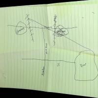
Hand-Drawn Map by Ann-Marie MacDonald
Item
Title
Hand-Drawn Map by Ann-Marie MacDonald
Description
The following is a description of the map in as simple terms as possible. See image for reference:
- "HIGHWAY 4" is written along a horizontal line near the top of the page.
- Intersecting with Highway 4 are two vertical lines covered in dashes, 7 in the first (closest to the left) and 11 in the second, which is also scribbled out.
- On the right of the second vertical line, there is a circular body that was labelled "QUARRY" and is scribbled out.
- On the left of the first vertical line is where this scribbled out circular body was replaced and labelled "QUARRY".
- Connected to Highway 41 is a long vertical line extending downwards which is intersecting with a horizontal line labelled "21") (presumably another highway but not labelled as such).
- On said vertical line, between Highway 41 and 21, it is labelled "dirt Road" and below 21, it is labelled "Rock Bass".
- On the very right of 21 is a larger circular, though not perfectly circular, body that is labelled "Base.".
- There is a diagonal line that connects the Base with the top of the vertical line with 7 dashes closest to the Quarry.
Creator
Ann-Marie MacDonald
Format
Drawing in black pen on lined paper
Language
English
Subject
The Way the Crow Flies
Source
From AMM's personal archive
