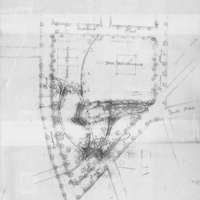
Map of Montebello Park, St. Catharines, 1887
Item
Title
Map of Montebello Park, St. Catharines, 1887
Description
Historic map showing Frederick Law Olmsted’s design for Montebello Park in St. Catharines, the first public park in the city’s downtown. The park is bordered by Ontario Street, Lake Street, Queen Street and Midland Street. A pavilion is shown near the centre of the park with pathways leading to it from each street. A baseball diamond is shown at the north corner of the park and tennis courts at the south corner. Trees line the streets and pathways. Handwritten dates and notations are visible. Authorship is indicated: “National Park Service, Frederick Law Olmsted National Historic Site”
Creator
Frederick Law Olmsted
Date
1887
Subject
Montebello Park (St. Catharines, Ont.)
Olmstead, Frederick Law
Olmstead, Frederick Law
Source
Map, Data, and GIS Library, Brock University