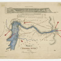
Sketch of Niagara River between Queenston and Chippawa
Item
Title
Sketch of Niagara River between Queenston and Chippawa
Description
Sketch of Niagara River between Queenston and Chippawa (coloured). Red arrows affixed to the map mark certain locations, including Lewiston; Queenston; the crossing over the Niagara River between Queenston and Lewiston; Portage Road; Ferry Miles (2 ½) over the River between Fort Schlosher and Chippawa Creek; and Chippawa. The map is engraved by J & C Walker, n.d.
Creator
J & C Walker
Subject
Map
Queenston (Ont.)--History
Queenston (Ont.)--History
Source
Alexander Hamilton/Early Canada Postal collection, RG 699, Archives and Special Collections, Brock University
